

A Non-Terrestrial Network (NTN) is a wireless communication system that utilizes space-borne or airborne platforms—such as satellites, high-altitude platforms (HAPs), or drones—to directly provide connectivity to devices on the ground. Within 3GPP, the term NTN generally refers to satellite and HAP-based systems.
The motivation for NTN is simple yet powerful: extending wireless coverage beyond the reach of terrestrial infrastructure. In remote areas, at sea, or in disaster-stricken zones, ground networks alone may not be cost-efficient or even feasible. By integrating NTN with existing cellular technologies such as 5G New Radio (NR), operators can deliver seamless coverage, economies of scale, and new service opportunities.
3GPP began formal work on NR-based NTN in 2017 with study items on scenarios and channel models, later followed by specifications in Release 17. While both satellites and HAPs are included, much of the focus has been on satellite-based NTN, since it demands broader specification updates. With these extensions, however, HAPS can also be supported, enabling a flexible framework for future NTN deployments.
As the industry evolves toward 6G, NTN is poised to play a central role in ensuring truly global connectivity—bringing the network not only to underserved rural areas but also to moving platforms such as ships, aircraft, and even remote IoT deployments
Satellite orbits and their characteristics
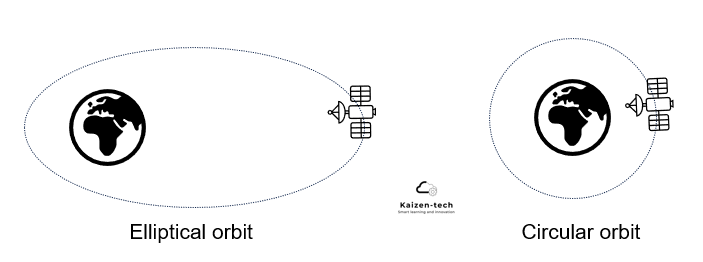
NTN are deployed across a broad spectrum of orbital altitudes, ranging from a few hundred kilometers above Earth to several tens of thousands of kilometers (Figure 1). Depending on their mission, these orbits may be circular or elliptical and can exhibit varying inclinations, defined as the angle between the orbital plane and the Earth’s equatorial plane (Figure 2).
Figure 1 : Source: Murata
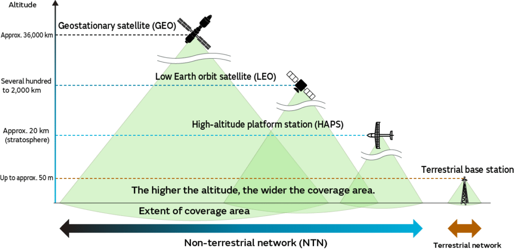
In terms of altitude, 3GPP’s work on Non-Terrestrial Networks (NTN) has primarily focused on satellites in geostationary orbit (GSO) and satellites in low Earth orbit (LEO)
In terms of altitude, 3GPP’s work on Non-Terrestrial Networks (NTN) has primarily focused on satellites in geostationary orbit (GSO) and satellites in low Earth orbit (LEO), as illustrated in Figure 1 a GSO satellite—also commonly referred to as a GEO (Geostationary Equatorial Orbit) satellite—follows a circular orbit aligned with the Earth’s equator at an altitude of approximately ~36,000 km
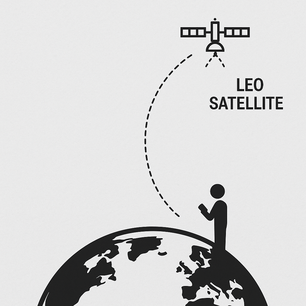
A Low Earth Orbit (LEO) satellite operates much closer to Earth, typically at altitudes between 500 km and 2,000 km. Its orbit may be circular or elliptical as described in Figure 2
Figure 2
The main advantage of a geostationary (GSO) satellite is that it remains fixed relative to Earth’s surface. From the ground, its position in the sky, and its coverage footprint appear constant, ensuring stable and continuous service over time. However, this stability comes at the cost of long signal travel distances. With a maximum satellite-to-device path of nearly 40,000 km, the one-way propagation delay ~ 133 ms, introducing significant latency compared to lower-altitude systems, making it less suitable for delay-sensitive services
A Low Earth Orbit (LEO) satellite operates at a much shorter distance to the device, resulting in lower path loss and significantly reduced propagation delay. However, the satellite moves at a speed of ~7.5 km/s, introducing a very large Doppler shift.
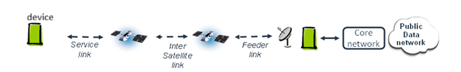
Link in satellite communication
In satellite systems, different types of links play a crucial role, as described in Figure 3:
- Service Link → The connection between the satellite and the user device (UE).
- Feeder Link → The connection between the satellite and the ground station, which anchors the satellite into the terrestrial network.
- Inter-Satellite Link (ISL) → Optional connection between satellites. These are especially important when a satellite lacks a direct line-of-sight to its ground station, allowing it to relay traffic via neighboring satellites before reaching Earth.
Figure 3: Links and satellite system
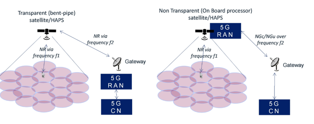
These link types form the foundation of satellite connectivity. How they are combined and processed depends on whether the satellite uses a transparent payload (amplify-and-forward, bent-pipe) or a regenerative payload (decode-and-forward, onboard gNB) as described in Figure 4
Together, the payload architecture and the types of links define how efficiently a Non-Terrestrial Network (NTN) can deliver seamless communication, whether via satellites in orbit.
Figure 4 : Transparent and regenerative payload from 3gpp
Satellite area coverage
Satellites often use steerable beams to keep coverage fixed over a target area on Earth. As the satellite moves, its beams are dynamically adjusted so the footprint on the ground stays aligned with the intended region.
When the satellite moves out of range and can no longer serve that area, the beam is redirected to a new region. At the same time, a new satellite coming into view takes over the coverage, ensuring continuous service for the area that was left behind.
Leave a Reply